
By Wendy Perla Kurtz on April 3, 2017
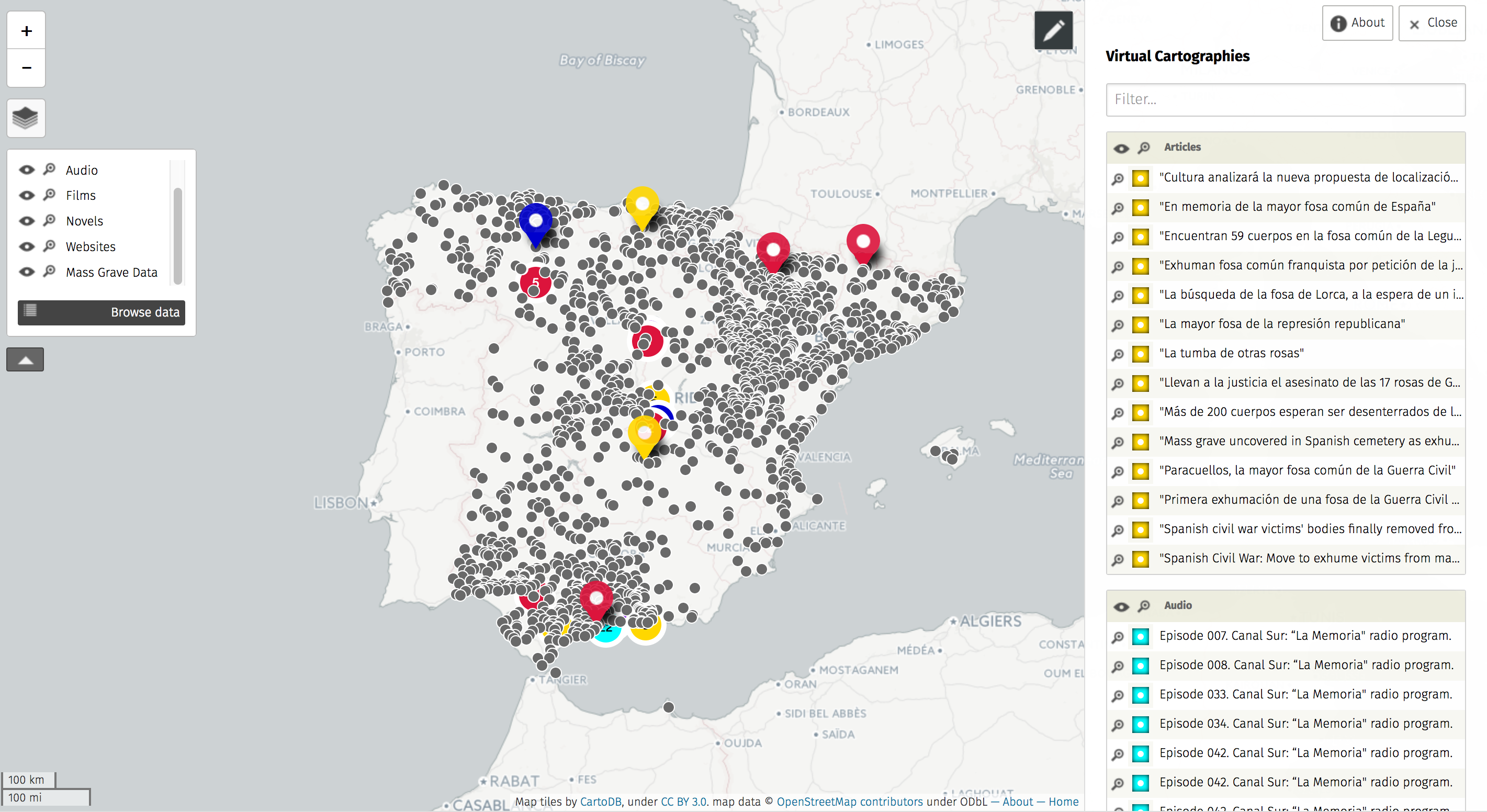 Digital mapping makes it possible to create layers upon layers of culturally, socially, and historically relevant materials to the recuperation of historical memory in Spain. As part of my dissertation (Mass Graves and Remembering through Ritual: Historical Memory in Contemporary Spanish Literature, Documentary Film, and Digital Media) I have constructed a digital map called Virtual Cartographies. By studying the performative aspect of the current disinterment and reburial process of mass graves dating back to the Spanish Civil War (1936-1939) and ensuing dictatorship of Francisco Franco (1939-1975), I reflect upon contemporary representations of loss and recovery of collective memory. Virtual Cartographies combines data collected from the Spanish Ministry of Justice—which identifies over 2,600 mass grave found throughout Spain—, with a rich corpus of multimedia texts directly related to specific gravesites [(including literary narratives, documentaries, YouTube films, radio programs, social media content, blogs, video games, academic and online news publications, as well as historical documentation found through the online Spanish National Historical archive (PARES).
 Recently I had the opportunity to present Virtual Cartographies at the Spatial Humanities 2016 Conference in Lancaster, England. The European Research Council supported this major European conference that was hosted by Lancaster University. The two-day conference program included speakers presenting on two simultaneous panels on various aspects of using GIS (Geographic Information Systems) to explore and show the contributions to knowledge that digital mapping technologies (GIS platforms) enable within and beyond the humanities. Some of the most exciting talks related to the use of digital maps to interpret literary texts for both research and pedagogical purposes. One of the panels focused on digital mapping and literature for the entire second day. What follows is a highlight of two particularly exciting presentations from those panels.
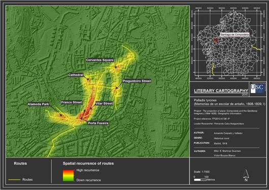
Dr. Maria Lopez Sandez presented on behalf of a group of researchers from the University of Santiago de Compostela in a talk titled: “The Use of Geographical Information Systems to Draw Literary Maps of Compostela: Applications in the Educational Field.” Over the past three years, the team has worked in combination with students to create literary maps of Santiago de Compostela in the Northwest region of Spain. The team used a body of texts pertaining to the estudiantina subgenre from Spain at the turn of the 20th-century, which depicts the life of university students in Santiago. They geolocated elements from the texts and created different visualizations of important literary spaces based off those elements in order to show the symbolic importance of different geographic areas. By geolocating the settings, routes, and zones that emerge from a close reading of the texts, the team built a database and corresponding visualizations that associate corresponding points, lines and polygons for those different “literary” spaces.
Dr. Meredith L. Goldsmith, Associate Professor of English at Ursinus College, in Montgomery County, PA, discussed her process for introducing students in the undergraduate classroom to using GIS technologies in the analysis of literature. In her talk, “‘Is New York Such a Labyrinth?’: Mapping Edith Wharton’s The Age of Innocence for the College Classroom,” Dr. Goldsmith spoke about her process of using GIS platforms with students, including how to turn a novel into a datasource and what types of questions can be explored when mapping literature. You can visit the project website, “Mapping Literary Visions,” which has examples of the maps used in class and her methodology, or you can read more about the research goals on her personal website.
 Attending Spatial Humanities 2016 was beneficial for a number of reasons. Most importantly, it provided a unique platform on which to present my current work to the targeted audience of the humanities mapping community. The conference was the first time I presented my dissertation research to a large audience and sharing my progress afforded me the opportunity to receive feedback at this critical junction of development. Attending the diverse presentations also allowed me to embed myself in discussions on contemporary practices for using GIS in teaching and research. The gathering prompted new avenues of consideration for my dissertation project and led to productive feedback, a great deal of networking, and connections with professors working within Spain and abroad.
More information about the speakers and presentations are available by downloading a full program with the project abstracts, or a short version of the program. Finally, I would like to thank the UCLA Center for Digital Humanities for their support in attending the conference, and for helping me get my map off the ground through their project support collaborations.
Featured image:
Exterior, InfoLab21, Lancaster University by Jisc infoNet. Modified (cropped) from the original and used under the Creative Commons Attribution-NonCommercial 2.0 Generic license. (https://www.flickr.com/photos/jiscinfonet/10821485826/in/photolist-hufWHQ-qLCfo1-qKPCyx-pXcxNY-8M4m4e-dYuUhZ-5DD89S-5Z8uZ2-8M7F8w-66zU8F-92kb56-6XQAPY-8M7oio-6g7jwR-5DCYUm-4Ue5XK-8M7nTJ-C1Jdxd-7basDs-5DyMUa-6g7jyg-5F95Ae-6LzwDn-55oARq-6fdfQQ-pP2uLn-phuMjG-bx6nh-5DD38o-s9gszu-5DyTp8-rfNsY-8M4Bok-qMm4PF-CZqWuz-mR9TC-7ULV9-sa5st2-8M4CDB-CjWFMC-nXSiZ-9puLep-8M4ABF-8M4kSK-qPjYtQ-987AZ2-5JViQt-phtP9K-8FXCgh-8M7EXy)
Additional image:
Campus buildings and trees by Michael Dunne. under the Creative Commons Attribution-NonCommercial 2.0 Generic license. (https://www.flickr.com/photos/michaeldunne/19676119483/in/photolist-vYHfPn-8FXwiY-7LJQzy-6vLMca-oe3hut-8FXy6b-8FXpo5-8FXDju-nULLwW-8FUgUn-8FXtkW-nULM2J-8FXwGE-5E2qv8-qwxGUz-feTCyY-7LJPMA-8FXzj1-MbRDw8-7LJRyE-5F1NFC-arTu6X-7LEnKp-JSEkh-qWV3B8-8FXvvs-9sK3Nc-nULuvj-7LJRiW-7LERh2-nULM7o-7LJjFu-9sK3J8-8FXvVN-Y3WfJ-5RX8in-7LERP8-nULUpF-ocghBR-8FUpHr-ocghtp-5E48JL-8FUoQP-nULLVm-NGnS8k-NDb35N-9sN41A-7LJjbL-8FXCZ1-oEdTxx)
Wendy Perla Kurtz is a PhD student in the UCLA Department of Spanish & Portuguese, and the Senior Research and Instructional Technology Consultant (RITC) at the Center for Digital Humanities. Her research focuses on contemporary Peninsular literature and film regarding the recuperation of historical memory from the Spanish Civil War. In her dissertation titled “Representations of Loss and Recovery in Contemporary Iberian Culture: Historical Memory from the Real to the Virtual,” she explores different strategies applied to represent loss and recovery in textual and visual media on historical memory from the 20th and 21st centuries in Spain.
Resources:
- Dr. Meredith L. Goldsmith, Associate Professor of English, Ursinus College – https://sites.duke.edu/meredithgoldsmith/
- Mapping Literary Visions Project – http://www.meredithgoldsmith.com/
- Spacial Humanities 2016 full program – http://www.lancaster.ac.uk/fass/projects/spatialhum.wordpress/wp-content/uploads/2016/02/SH2016_ProgrammeFullFinal1.0.pdf
- Spacial Humanities 2016 short program – http://www.lancaster.ac.uk/fass/projects/spatialhum.wordpress/wp-content/uploads/2016/02/SH2016_ShortProgramme.pdf
- Spanish Ministry of Justice – http://www.memoriahistorica.gob.es/es-es/mapafosas/Paginas/index.aspx
- Virtual Cartographies – http://www.virtualcartographies.com/