 Website: http://idastorm.bol.ucla.edu/researchstudy.html
Principal Investigator(s): Prof. Tim Tangherlini, Scandinavian
Website: http://idastorm.bol.ucla.edu/researchstudy.html
Principal Investigator(s): Prof. Tim Tangherlini, Scandinavian
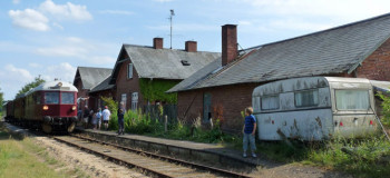
An ongoing challenge for many historical GIS projects is the aggregation of data from disparate sources. In our project, we aim to bring together sources describing changes in infrastructure, population, and farming methods from the mid 19th century to the early 20th century in Denmark. This period was one of considerable change throughout Scandinavia, with a shift from a manorial system to a free market organization of land, the advent of ubiquitous transportation and more sophisticated communication, the rise of universal literacy, and profound shifts in political and religious affiliations. Our past year of work has focused on mapping population change at the level of parish for the target period, as well as developing a dynamic map of infrastructure development focusing on the railways. In the coming years, we aim to add parish level data including: agricultural and economic information such as land use and animal census, political information such as vote tallies, development information such as hearths, educational information such as primary, secondary and tertiary schools, and religious information such as church affiliations and minister appointments. This multi-layered data will provide a rich historical background for the study of cultural data useful for the study of folklore, art, literature, and other cultural expressive forms. The approach is scalable, and we hope to include similar data for Norway and Sweden in the coming years.
Tim Tangherlini & Ida Storm – lightning talk at project showcase event on April 8, 2015:
https://www.youtube.com/watch?v=SWR68WDYdGI