
- This event has passed.
New Light on Henricus Martellus’s World Map at Yale (c. 1491): Multispectral Imaging and Early Renaissance Cartography
February 11, 2016 @ 12:00 pm - 1:30 pm
Seating is limited. Please RSVP to mposner@humnet.ucla.edu.
Chet Van Duzer
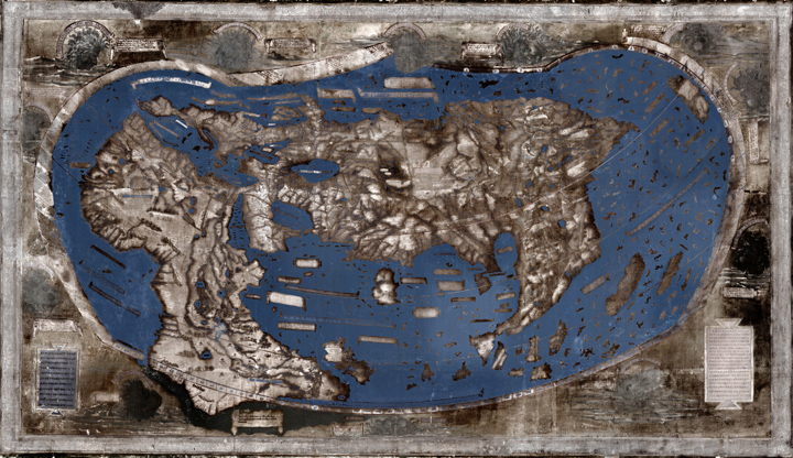
In this talk I will give an account of a recent NEH-funded project to make multispectral images of a world map made by Henricus Martellus in about 1491, which is held by the Beinecke Library at Yale. This large map has long been thought to be one of the most important of the fifteenth century, and was thought to have influenced Martin Waldseemüller’s world map of 1507, but the many texts on the map were illegible due to fading and damage, and thus its exact place in Renaissance cartography was impossible to determine. The new multispectral images have rendered many of the previously illegible texts on the map legible. I will explain why the Martellus map was an excellent candidate for multispectral imaging, describe the process of making the images, show some of the results, and give an account of the place of the Martellus map in late fifteenth- and early sixteenth-century cartography.
 Chet Van Duzer has published extensively on medieval and Renaissance maps in journals such as Imago Mundi, Terrae Incognitae and Word & Image. He is also the author of Johann Schöner’s Globe of 1515: Transcription and Study, the first detailed analysis of one of the earliest surviving terrestrial globes that includes the New World; and (with John Hessler) Seeing the World Anew: The Radical Vision of Martin Waldseemüller’s 1507 & 1516 World Maps. His book Sea Monsters on Medieval and Renaissance Maps was published in 2013 by the British Library, and in 2014 the Library of Congress published a study of Christopher Columbus’s Book of Privileges which he co-authored with John Hessler and Daniel De Simone. His book The World for a King: Pierre Desceliers’ Map of 1550 is just out (November 2015) from the British Library, and Brill has just published (December 2015) a book he co-authored with Ilya Dines, Apocalyptic Cartography: Thematic Maps and the End of the World in a Fifteenth-Century Manuscript. His current book project is a study of Henricus Martellus’s world map of c. 1491 at Yale University based on multispectral imagery.